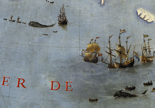
A close-up of the Earth Globe by Coronelli in which narration has a strong relevance.
Extracts from Italo Calvino’s “Collection of sand”, 1980
The simplest form of a map isn’t the one we consider the most natural today, that is the map which represents the surface of the Earth as seen by an extra-terrestrial eye. The early need of fixing places on a map has got references to the topic of “journey”: it’s like the reminder of a series of steps, the layout of a route. The simplest map is a linear image, which can only be drawn on a long paper scroll. Roman maps were in fact scrolls of parchment paper: today we can understand how they were designed thanks to a surviving medieval copy, the «Pautinger’s plate», which includes the imperial road system from Spain to Turkey.
The overall vision of the then known world looks horizontally flattened as a result of an anamorphic transformation. Since the map focused only on the land roads, the Mediterranean Sea was reduced to a thin horizontal wavy stripe between two wider areas (Europe and Africa), so much so that Provence and North Africa look very close to each other and so Palestine and Anatolia.
[…]
Halfway between cartography and landscape painting, a japanese paper scroll which dates back to 1700, is 19 meters long and represents the route from Tokyo to Kyoto: this is a very detailed landscape in which it’s possible to see where the road surpasses high grounds, goes through groves, borders villages, overcomes rivers crossing a little arched bridge, adapts its course according to the extremely variable land conformations. The outcome is a scenery which is always pleasant for the eyes, lacking in human figures although is full of signs of real life. (The starting point and the arrival, that is the two cities, are not in the map: their look would have certainly fought back with the harmony of the landscape). The japanese scroll invites us to identify ourselves with the invisible traveller, to cover that road bend after bend, to climb up and down the little bridges and the hills.
Taking a course from start to end, gives us a particular gratification, both in life and literature (the journey as a narrative structure) so we should ask ourselves why was the topic of “journey” so underestimated in visual arts where it appears only sporadically.
[…]
Understanding an image through time and space is essential in cartography. Time assumed as past story: I’m thinking of Aztec maps always full of visual representations of historical and narrative tales, but also of medieval maps […]. And time as future: think for instance at the presence of possible obstacles scattered along the planned route […].
Therefore a map, even if it’s static, requires a narrative idea behind itself, it is conceived for an itinerary, it’s an Odyssey.
[…] François Wahl once noticed how earth representation was a practice started only when men began to refer ordinary sky grid reference to Earth. Doing that, sky parameters (like polar axis and equatorial plane, meridians and parallels) became Earth parameters, positioned on the surface of our globe, that is the center of universe («the most fruitful error ever»).
[…] «We had chance to describe the Earth just because we have projected the sky over it».Â
Calvino wrote this inspiring notes after a visit to the exhibition «Maps and figures of the Earth» held at the Centre Georges Pompidou in Paris on 1980.
He had chance to see the biggest globe ever built, ordered by Louis XIV to Venetian friar Vincenzo Coronelli, which had been dismantled in boxes at Versailles for about two hundred years until then.
He describes it this way:
[…] But the greatest surprise of all was the globe, in shades of brown and ocher, with pictures engraved on its surface (like brutal practices of savage cannibals) and inscriptions coming from news brought by explorers and missionaries who filled the gaps where the shape of places was still uncertain.
To Coronelli, California was an island, so he commented in a caption: «Some fools are saying that California is a peninsula …» And in an another point: «Here it is said that there’s an island, but it is false and I do not put it ». As for the sources of the Nile, after having placed them in a precise area and later moved in order to a new witness, Coronelli ultimately wrote down a text near the river, which candidly concludes with these words: «I have found myself with a space to fill and there I wrote these words».
[…]
We must say that it is only with the progress of exploration that the undiscovered world gained the right to appear in a map. What was not seen before, simply didn’t exist. Paris exhibition highlights this aspect of knowledge in which each new acquisition opens new awareness of gaps […].
The moral that emerges from the history of cartography is always a matter of reduction of human ambitions. If in the Roman map the pride to identify the entire world with the Empire itself was implicit, we see Europe becoming small in comparison to the rest of the world in the map drawn by Fra Mauro (1459), one of the first map of the world designed according to Marco Polo’s reports and to the experiences of Circumnavigation of Africa: in this map the reversal of the cardinal points accentuates the reversal of perspectives.
It’s as if the representation of the world on a limited area, would automatically set it as a microcosm, suggesting that there’s a larger world by which is contained. For this reason the map is often the border between two geographies, the one made of parts and the one made of the whole, the one of the entire earth and the one of the sky, which can be taken as astronomical firmament or kingdom of God. […]
From all these aspects we can learn how much subjectivity is important in cartography, which usually is conceived as a purely objective task.
[…]
Regarding the reasons that lead us to design maps, Calvino wrote a clever observation that examines the relationship between cartography that looks at “elsewhere” and the one that focuses on familiar territory. To Calvino, there’s always a tight link between the two, as explained with this anecdote.
In the seventeenth century the French fleet expansion required a regular production of timber, but the forests of France were running out. Then Colbert (translator’s note: the French minister of finance from 1665 to 1683) felt the need for a comprehensive relief map of French forests, in order to have always under control the amount of available trees and to plan rationally refueling and transport of timber to shipyards. At that precise moment in France, just to support maritime expanding, geographical knowledge of the internal territory bacame the primary need.

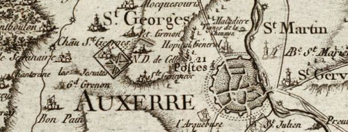
A detail of the famous Cassini’s map of France. Here it is a part of Bourgogne.
As explained by Calvino, Colbert charged Gian Domenico Cassini with the design of this extremely detailed map which took him and his family (four different generations of Cassini’s) more than 60 years to complete. The final map was drawn to scale of 1 to 86.400 and was…
… shown in the exhibition in a reproduction that was spreading all over the walls and the floor. Each forest had been designed tree to tree, every church had its steeple, every village had been squared roof to roof, so one could have had the unbelievable impression of having every tree and every bell and all the roofs of the Kingdom of France under his/her eyes. […]
Cassini’s map missed the human figures that Coronelli still felt the need to include in its globe; but it’s just the fact that these cards are deserted, uninhabited, that awaken in the desire to live them from within, to shrink ourselves to find a road into the thickness of signs, to cover it, to get lost in it.
I’ve found this gorgeous website by Didier Verlaque, who joined all the pieces of Cassini’s map (in high definition reproduction), rebuilding the entire France as seen with the eyes of the seventeenth century.
http://releves.hd.free.fr/cassini/
I’d like to thank him for the great work.
But if you are more experienced with flickr, this is a set of photos of the Cassini’s map with the same awesome high definition:
http://flickr.com/photos/derami/sets/72157594402072857/
Images and additional info for the post, was taken from:
http://www.cg78.fr/culturel/musees/dossier/dossier.asp?Id=21
http://www.groupe-bovis.com/article.php3?id_article=68
http://expositions.bnf.fr/globes/index.htm
http://fr.wikipedia.org/wiki/Globes_de_Coronelli

