Designing Connected Places is the slogan of the International Summer School, an initiative of great interest in the calendar of Torino 2008 World Design Capital, which led students and teachers to look at the territory of Piemonte understood as a complex network of social co-existence and production processes. The six workshops were held at the University of Gastronomic Sciences of Pollenzo under the banner of the promotion of effective and original local development strategies linked to the following emergencies: citizens’ health and well-being, sustainable urban mobility, security and quality of life in the city, new distribution networks of local food products, advanced systems of representation of complex phenomena that involve local communities, and distributed re-organization of production facilities. The summer school brings out a new definition of the ÔÇťlocalÔÇŁ and a new role of design: a connected local, understood as local in the era of networks and high connectivity, understood as a concept able to promote original development strategies.
About Complexity Maps
Torino is a city on the move. The tradition forms of representation are obsolete or inadequate to depict the current reality and the dynamics in progress. How can the city be made legible and comprehensible, understood as a complex organism and as a web of physical and social networks? The urban territory is a system whose complexity is growing, in which a multitude of tangible and intangible flows (people, goods, information) stratify and interconnect.
Faced with all this, the traditional modes of mapping and representing the city appear entirely inadequate: the representations of the new physical and social networks, like that of their individual and collective life, are a new challenge for the design of communication. The representation of the phenomena demands the gradual abandonment of classical visual languages, i.e. of maps that lay their trust chiefly in the topological and geographical metaphor.
Overcoming these limits means building a new representation of the city: a collective vision capable of defining and visualizing the new concept of urban space and, more in general, social spaces. The theme, proposed in collaboration with the Urban Center Metropolitano of Torino, aims to produce visualizations in the form of diagrams and maps of relationships that induce a new way of viewing human-city interaction, and also useful for outlining new criteria for its development.
Workshop leader : Christian Nold
Workshop assistant : Jim Segers
MetaDesign team: Paolo Ciuccarelli, Donato Ricci
Commitment : Urban Center Metropolitano – Torino
Brief
This project has a specific target area as well as a partner organization. The focus is on a socially deprived area in the north of Turin, earmarked for future development by the Urban Centre our partner organization. Our challenge is to complement the Urban CentreÔÇÖs long term and strategic understanding of this place with the complexity of views and agendas of local people. We will experiment with the concept of the ÔÇśActor-NetworkÔÇÖ and treat our site as a complicated entity made up of a range of competing actors with different interests.
Challenges
Consultation
How can we develop a range of ad hoc ethnographic techniques to engage with local people and get past the language barrier and collect holistic ÔÇśdataÔÇÖ about the local actor network? We suggest to organise a community event that will draw in skills and resources from the local community, while at the same time establishing a meeting space where local actors come together. The setting up of the event will provide an opportunity to contact different stakeholders in the community, and to gather data on their role and visions of the future of their local area. The event itself is an opportunity to bring together and collect different visions of the future.
Visualizations
How can we analyze, visualize and communicate the complicated local networks to our project partner, the local participants and a wider public?
The students worked in small groups on a broad range of themes that overlap strongly with the other workshops: People, History and Future, (In)security, Environment, Mobility.
This workshop has been ambitious in attempting to create a very broad way of looking at a very specific place, so we benefit from connections with the other workshops that create more detailed analyses of a particular topic. We also generated a lot of new data about the project area. Since the aim of this workshop is to develop visualizations we focused on the final presentation and communication of our results. The aim was to have a whole wall that will represent the target location from a multiplicity of perspectives.
Output
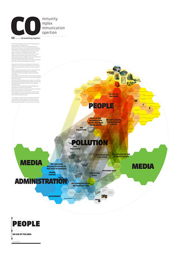
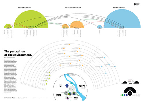
Environment Group
How are the local people engaged with their surroundings? What effect does the environment have? Who uses the river area? Why is it being used? Are there environmental pollutants in the area? How could we measure them? Who holds the data for this sort of thing? Who is resoponsible for dealing with it? What could local people do to engage with possible pollution? How do we visulise all the relevant actors in this network?
Main Research Conclusion:
The lack of communication between different kinds of actors (people, media, administration) overshadows the environmental and pollution problem of the project area.
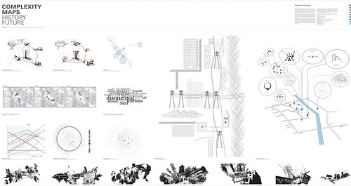
History / Future Group
Who decides the future of this place? What do local people think will happen? How involved are they in the planning processes taking place? What affect will the proposed changes have on the local area? How can we communicate some of the proposals? How can we make the Golf Course proposal physically imaginable in the space? What might be the unexpected effects of these proposals? Can we come up with better ideas? What plans do local people have? Are there any temporary interventions that might change the place? How can we visualise alternative local visions of the future?
Main Research Conclusion:
In the past social systems like the illegal allotments kept the connections between local actors alive. The place has been disconnected through top down design actions.
Mobility Group
How do local people move about in the area and where are they trying to get to? Where do people work? Are people using public transport? With all the planned changes how will this impact their future travel possibilities? Who is responsible for planning these sort of things? How will the people who use the Golf Course get there? What impact will this have on the local area? How is mobility affecting the local sense of place and quality of life? What do people think should be done? How can we work with the other mobility workshop taking place?
Main Research Conclusion:
The current use of the park has been entirely determined by the a series of external factors that suggest its future dynamics
People Group
Who are the different groups of people who use and/or own this place? What different uses do they make of the space? What completing needs and requiremetns do they have? What are their aims, wishes and desires? Are the concepts of ownership or stakeholders the right way to change the area? How can we visualise these power relations?
Main Research Conclusion:
The locked loops of local policy and money perpetuate a situation of local abandonment which feeds illegal activities and social & political exclusion.
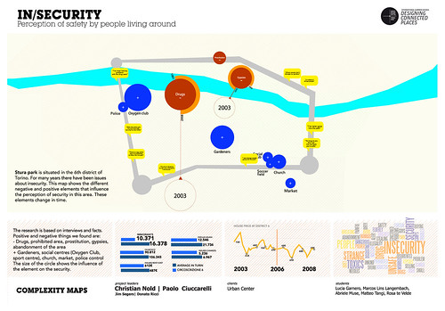
(In)Security Group
What does security or insecurity means in the local context? What are peopleÔÇÖs local fears? Is it really about the drug dealing or about jobs or whatever? Who is creating these feelings of security or insecurity? Are the planned developments going to help with this? Are there particular groups being targeted in the local area? Are the local allotments under threat? What do the local newspapers say about these issues? Do the local shops have a different opinion from the local residents? Are there differnces of opinion? How can we visulise these differnces?
Main Research Conclusion:
the perception of safety in the area changed between 2003 and 2008.


[…] bookmarks tagged newspapers Torino World Design Capital – Designing Connected … saved by 5 others uknowucant bookmarked on 08/03/08 | […]
August 3rd, 2008 at 1:21 pm[…] Torino World Design Capital – Designing Connected Places Summer School – Complexity Maps […] Designing Connected Places is the slogan of the International Summer School, an initiative of great interest in the calendar of Torino 2008 World Design Capital, which led students and teachers to look at the territory of Piemonte understood as a complex network of social co-existence and production processes.[…] […]
September 12th, 2008 at 4:44 am[…] Torino World Design Capital – Designing Connected Places Summer School – Complexity Maps […] Designing Connected Places is the slogan of the International Summer School, an initiative of great interest in the calendar of Torino 2008 World Design Capital, which led students and teachers to look at the territory of Piemonte understood as a complex network of social co-existence and production processes.[…] […]
September 14th, 2008 at 5:16 am[…] – bookmarked by 6 members originally found by djalmaaguiar on 2008-10-11 Torino World Design Capital – Designing Connected Places Summer … […]
October 24th, 2008 at 5:30 am