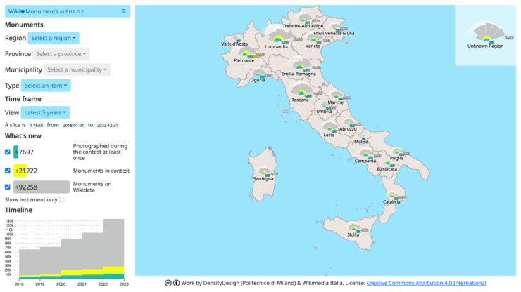
data.wikilovesmonuments.it is a visualization platform designed for Wikimedia Italia. The project is built around Wiki Loves Monuments Italy (WLM), a contest that fosters the Wikimedia Community to depict and share photographs of monuments on Wikimedia Commons, under an open license. Thanks to the visualization, it is possible to explore Italian territories and display the photographic coverage of cultural properties over different time frames. By doing so, Wikimedia staff and volunteers can address the community’s effort and organize photographic or mapping activities.
The design process was predominantly driven by information obtained through co-design activities. Designers employed them to learn about different aspects of the project, such as the WLM contest goal, evaluation process, or the Wikimedia infrastructures. Guiding principles were defined by designers and commissioners together, during a generative workshop whose preparation was informed by desk research and semi-structured interviews. Designers then synthesized them in form of a mind-map and, after rediscussing the outcome with commissioners, started an implementation process supported by solid prescriptions and extensive contextual knowledge.
Extensive efforts were invested in understanding how to automatically collect data from Wikidata and Commons. The task wasn’t trivial, mainly because the meaning of “monument” can be very elusive and it includes many different things: sculptures, buildings, monumental trees, parks, etc. We came up with an approach that defines monuments as Wikidata entities, collected in two ways. First, we collect cultural properties from manually curated lists by organizers of WLM, then we merge them with other lists obtained through SPARQL queries. More specifically, the queries are built around 18 instance types representing cultural properties and defined in previous research conducted by Synapta and Wikimedia.
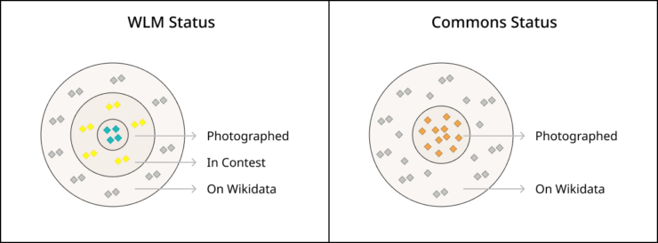
The visualization deals with more than 130.000 cultural properties. For each of them we harvest a number of different details, like the creation date on Wikidata, the date in which it was put in contest, the relevant images, and all the images created thanks to the contest. By combining such information, we reconstruct the history of monuments statuses, and, through data aggregation, we show coverage over territories. We have two types of statuses, that we called “WLM status” and “Commons status”. The first describes monuments from the point of view of the contest: they can be “photographed” (at least one time), put “in contest”, or simply “on Wikidata”. The logic of the second status doesn’t take the contest into account: a monument is “photographed” if we retrieved at least one picture from Commons, otherwise is just “on Wikidata”.
The differentiation between the two statuses helps in appreciating the results of the contest and, in addition, brings attention to the matter of freedom of panorama in Italy, limited by the Italian “Code of Cultural Heritage and Landscape” (Legislative Decree No. 42, dated January 22, 2004, and its subsequent amendments). The legislative decree allows the reproduction of Italian cultural property for personal use or study, but requires a further authorization for any other purpose, such as the commercial use. Because of the open license adopted by Wikimedia projects (e.g., CC-BY-SA or CC-0), organizers of the contest must ask managers of cultural properties the permission to publish WLM pictures, differently from most European countries. If they get the permissions monuments are put in contest.
The statuses are conceptualized with the use of Euler diagrams. As visible in the picture, the status “photographed” is always the most inner subset. In the case of WLM, the photographed monuments are a subset of the “in contest” monuments, which in turn is subset of all the monuments inserted on Wikidata. Photographed monuments are a subset of Wikidata elements also in the case of Commons status. However, since we don’t check their participation in to the contest, the usage of their picture for commercial scopes may be not allowed. For instance, this is the case of Colosseo.
The project employs a custom visual model based on a data-driven fan, leveraging slices to display the history of aggregated monuments statuses. In the visualization we generate a fan for each for Italian administrative areas in the view (i.e., regions, provinces, and municipalities) to see progresses over days, months, or years.
In addition, we added a secondary exploration mode based on a list, suitable to access and download data about individual monuments.
The current version of the project (alpha 0.2) is publicly accessible at data.wikilovesmonuments.it


 .
. 

